
Chania Travel Guide
Famous Beaches
Elafonisi is located 86km west of Kalyves and 5km south of Chrysoskalitisa Monastery, in the southwesternmost tip of Crete. Elafonisi is an oblong peninsula, which often breaks in two parts by water giving the impression of being a separate island. It is a Natura 2000 protected area. The island is full of sand dunes with sea daffodils and jupiners. The endangered loggerhead sea turtle and several more rare animals and plants find shelter on the island.
Exotic beaches with white sand and turquoise water, reminding of the Caribbean, are formed on either sides of the peninsula. The sand is pinkish in many places, taking its color from millions of crushed shells. Near the breaking point of the peninsula, the sea water does not exceed 1m in depth, creating a small lagoon, ideal for children. You can easily cross the lagoon in order to reach the opposite site of the peninsula, while carrying your staff with you, because the water is very shallow there.
The eastern side of the beach, in front of the lagoon, is well organized and has the most people. There are umbrellas, showers, lifeguards, snack bars and changing rooms. Also, near the beach there is a huge area for parking. Opposedly, the beaches on either sides of the island are less crowded and are the most beautiful, with amazing azure colors. There are some coves available for naturists near the west end of the peninsula.
362 personas del lugar lo recomiendan
Playa Elafonissi
Elafonisi is located 86km west of Kalyves and 5km south of Chrysoskalitisa Monastery, in the southwesternmost tip of Crete. Elafonisi is an oblong peninsula, which often breaks in two parts by water giving the impression of being a separate island. It is a Natura 2000 protected area. The island is full of sand dunes with sea daffodils and jupiners. The endangered loggerhead sea turtle and several more rare animals and plants find shelter on the island.
Exotic beaches with white sand and turquoise water, reminding of the Caribbean, are formed on either sides of the peninsula. The sand is pinkish in many places, taking its color from millions of crushed shells. Near the breaking point of the peninsula, the sea water does not exceed 1m in depth, creating a small lagoon, ideal for children. You can easily cross the lagoon in order to reach the opposite site of the peninsula, while carrying your staff with you, because the water is very shallow there.
The eastern side of the beach, in front of the lagoon, is well organized and has the most people. There are umbrellas, showers, lifeguards, snack bars and changing rooms. Also, near the beach there is a huge area for parking. Opposedly, the beaches on either sides of the island are less crowded and are the most beautiful, with amazing azure colors. There are some coves available for naturists near the west end of the peninsula.
The famous lagoon of Balos is located approximately 70km west of Kalyves and 17km northwest of Kissamos, formed between the Cape Gramvousa and the small Cape Tigani and below the range of Platiskinos. Balos is surely the mostly photographed beach in Crete, a very favorite subject of all tourist guides for Greece.
Balos is famous for its turquoise waters, the wild natural beauty and the beautiful exotic scenery. During the summer, it is visited by thousands of people, who arrive mostly by the ferries running from Kissamos port. Also, a perfect idea is to arrive at Balos in the morning, before the boats arrive from Kissamos. These few hours of remoteness in such a heavenly place will remain etched in your memory forever.
The lagoon of Balos has white sand and exotic white, vivid blue and turquoise waters. The sea is very shallow and warm, ideal for young children. In many places the sand has a lovely pinkish color, because of millions of crushed shells. Beyond the rocks at the boundaries of the lagoon, the water is deeper and colder, ideal for a snorkeling. The lagoon and the wider area, with rare species of flora and fauna, are protected under the Natura 2000 program. Eleonora falcons, shags and cormorants nest in the caves of the area. Moreover, the area is a shelter for the protected monk seal and the loggerhead sea turtle (Caretta caretta). Despite the protection, some canteens and umbrellas have appeared on the beach in recent years.
ACCESS
The first and easiest way is to take the morning ferry from Kissamos (around 25 to 30 Euros). You'll have the chance to see the wild shores of peninsula Gramvousa and the marks from their lifting up for 6-9m after a strong earthquake in 365AD. If you're lucky, you might be accompanied by dolphins. Furthermore, the ferry will leave you for a swim in the exotic beach of Imeri Gramvousa islet, where you will see the old fortress and the wrecked ship.
If you do not want to come by boat and have a car, you can drive in the dirt road, starting from Kaliviani and running along the Cape Gramvousa. Near Kaliviani you have to pay a small fee destined for the protection of the Gramvousa Reserve and preservation of the road. After 10km the road stops at a wide parking area, next to a canteen, just over the lagoon. The panoramic view of Balos and the island of the Gramvousa is breathtaking. From there, you can walk down in the 1km longpath leading to the beach. Return to the parking area is quite strenuous and tiring due to the inclination.
515 personas del lugar lo recomiendan
Playa Balos
The famous lagoon of Balos is located approximately 70km west of Kalyves and 17km northwest of Kissamos, formed between the Cape Gramvousa and the small Cape Tigani and below the range of Platiskinos. Balos is surely the mostly photographed beach in Crete, a very favorite subject of all tourist guides for Greece.
Balos is famous for its turquoise waters, the wild natural beauty and the beautiful exotic scenery. During the summer, it is visited by thousands of people, who arrive mostly by the ferries running from Kissamos port. Also, a perfect idea is to arrive at Balos in the morning, before the boats arrive from Kissamos. These few hours of remoteness in such a heavenly place will remain etched in your memory forever.
The lagoon of Balos has white sand and exotic white, vivid blue and turquoise waters. The sea is very shallow and warm, ideal for young children. In many places the sand has a lovely pinkish color, because of millions of crushed shells. Beyond the rocks at the boundaries of the lagoon, the water is deeper and colder, ideal for a snorkeling. The lagoon and the wider area, with rare species of flora and fauna, are protected under the Natura 2000 program. Eleonora falcons, shags and cormorants nest in the caves of the area. Moreover, the area is a shelter for the protected monk seal and the loggerhead sea turtle (Caretta caretta). Despite the protection, some canteens and umbrellas have appeared on the beach in recent years.
ACCESS
The first and easiest way is to take the morning ferry from Kissamos (around 25 to 30 Euros). You'll have the chance to see the wild shores of peninsula Gramvousa and the marks from their lifting up for 6-9m after a strong earthquake in 365AD. If you're lucky, you might be accompanied by dolphins. Furthermore, the ferry will leave you for a swim in the exotic beach of Imeri Gramvousa islet, where you will see the old fortress and the wrecked ship.
If you do not want to come by boat and have a car, you can drive in the dirt road, starting from Kaliviani and running along the Cape Gramvousa. Near Kaliviani you have to pay a small fee destined for the protection of the Gramvousa Reserve and preservation of the road. After 10km the road stops at a wide parking area, next to a canteen, just over the lagoon. The panoramic view of Balos and the island of the Gramvousa is breathtaking. From there, you can walk down in the 1km longpath leading to the beach. Return to the parking area is quite strenuous and tiring due to the inclination.
The exotic beach of Falassarna is located 67km west of Kalyves, at the western base of peninsula Gramvousa. At the northern end of the beach there are the ruins of the ancient Grecoroman city of Phalassarna.
Falassarna bay hosts some of the most famous beaches in Greece, which has been awarded as the best beach of Crete and voted as one of the 10 best beaches in Europe several times in the past. Falasarna spans a large area and consists actually of five consecutive beaches, with the two most central being the most favorite.
The sand in Falassarna is whitish, making the water color tropical. Indeed, if you're lucky and be here on a day that is not blowing from the west (rare in west Crete) you will be enchanted by the beach and its turquoise waters.
The main beach of Falassarna is called Pachia Ammos (i..e Coarse Sand). It is an exotic beach with a length of 1km and a width of 150m. This beach attracts the most visitors of the area, but because of its length it never seems too crowded. The beach offers umbrellas and a few snack bars and cafes, where you can get food and water. There are also services for water sports and beach volley courts.
The area around Falassarna is magnificent and is a protected nature reserve. If you have time and are looking for something romantic, you can wait for the sunset, which is considered the best in Crete.
One drawback about Falasarna is that it looks west and is usually wavy. However, this is desired by windsurfers.
If you do not have a mean to get in Falassarna, you can catch the bus from Chania.
369 personas del lugar lo recomiendan
Phalasarna
The exotic beach of Falassarna is located 67km west of Kalyves, at the western base of peninsula Gramvousa. At the northern end of the beach there are the ruins of the ancient Grecoroman city of Phalassarna.
Falassarna bay hosts some of the most famous beaches in Greece, which has been awarded as the best beach of Crete and voted as one of the 10 best beaches in Europe several times in the past. Falasarna spans a large area and consists actually of five consecutive beaches, with the two most central being the most favorite.
The sand in Falassarna is whitish, making the water color tropical. Indeed, if you're lucky and be here on a day that is not blowing from the west (rare in west Crete) you will be enchanted by the beach and its turquoise waters.
The main beach of Falassarna is called Pachia Ammos (i..e Coarse Sand). It is an exotic beach with a length of 1km and a width of 150m. This beach attracts the most visitors of the area, but because of its length it never seems too crowded. The beach offers umbrellas and a few snack bars and cafes, where you can get food and water. There are also services for water sports and beach volley courts.
The area around Falassarna is magnificent and is a protected nature reserve. If you have time and are looking for something romantic, you can wait for the sunset, which is considered the best in Crete.
One drawback about Falasarna is that it looks west and is usually wavy. However, this is desired by windsurfers.
If you do not have a mean to get in Falassarna, you can catch the bus from Chania.
Stefanou beach is located at the position of Seitan Limania (i.e. satan harbours), 34km north of Kalyves. The wider area is named Seitan Limania, after the wild landscape, the steep cliffs and the strong sea streams which are considered dangerous. Here are situated three parallel narrow coves, well protected from the waves.
In the northern cove a tiny fantastic beach is shaped, with deep azure waters, namely the beach of Stefanou. The beach has fine pebbles and sand. On the right and the left sides of the cove, huge marble rocks are standing high to protect the beach from the bad weather. The fame of the beach has faced a rapid increase since 2010, some years after the asphalt road reached the place; the beach is crowded in during peak season. There is a narrow steep path starting from the parking place and leading to the beach, so make sure you wear sneakers.
239 personas del lugar lo recomiendan
Playa Seitan Limania
Stefanou beach is located at the position of Seitan Limania (i.e. satan harbours), 34km north of Kalyves. The wider area is named Seitan Limania, after the wild landscape, the steep cliffs and the strong sea streams which are considered dangerous. Here are situated three parallel narrow coves, well protected from the waves.
In the northern cove a tiny fantastic beach is shaped, with deep azure waters, namely the beach of Stefanou. The beach has fine pebbles and sand. On the right and the left sides of the cove, huge marble rocks are standing high to protect the beach from the bad weather. The fame of the beach has faced a rapid increase since 2010, some years after the asphalt road reached the place; the beach is crowded in during peak season. There is a narrow steep path starting from the parking place and leading to the beach, so make sure you wear sneakers.
Kedrodasos (i.e. juniper wood) is an amazing beach, located 89km southwest of Kalyves and 1km east of the famous Elafonissi lagoon. The beach is full with juniper trees (mistakenly confused with cedars) and sanddunes. These are the small twisted junipers (juniper species are Juniperus oxycedrus subsp. macrocarpa and Juniperus phoenicea). If you ever visit the beach, you should note that the trees are very fragile and need respect.
The "cedar" grove covers a big area of about 11 hectares and is a magnificent place. It is a wonderful choice for swimming and a favorite beach for naturists. It is a very nice beach with white sand and some smooth and flat rocks in places. Fortunately, there are no facilities nearby, making this secluded beach, one of the latest untouched paradises in Europe. Moreover, since the beach is secluded, you should keep it clean and not littered.
The beach is protected to some point from the winds that usually blow in the neighboring Elafonissos. The European path E4 crosses the beach (there are yellow and black signs on the way).
144 personas del lugar lo recomiendan
Playa Kedrodasos
Kedrodasos (i.e. juniper wood) is an amazing beach, located 89km southwest of Kalyves and 1km east of the famous Elafonissi lagoon. The beach is full with juniper trees (mistakenly confused with cedars) and sanddunes. These are the small twisted junipers (juniper species are Juniperus oxycedrus subsp. macrocarpa and Juniperus phoenicea). If you ever visit the beach, you should note that the trees are very fragile and need respect.
The "cedar" grove covers a big area of about 11 hectares and is a magnificent place. It is a wonderful choice for swimming and a favorite beach for naturists. It is a very nice beach with white sand and some smooth and flat rocks in places. Fortunately, there are no facilities nearby, making this secluded beach, one of the latest untouched paradises in Europe. Moreover, since the beach is secluded, you should keep it clean and not littered.
The beach is protected to some point from the winds that usually blow in the neighboring Elafonissos. The European path E4 crosses the beach (there are yellow and black signs on the way).
Stavros (i.e. cross) is a seaside village located 29km north of Kalyves, at the northernmost edge of Cape Akrotiri. One characteristic feature of the area is the very steep camel-shaped mountain Vardies rising opposite the harbor of Stavros. The mountain is famous, because there were filmed scenes for the Oscars winning film “Zorba the Greek”, where Anthony Quinn danced the famous Sirtaki Dance in 1964. Then Stavros was a humble small fishing village.
The main beach is located east of the village, at the foot of the mountain Vardies, and next to the picturesque harbor. A semicircular lagoon is formed, fully protected by winds blowing in the region. The small bay has marvelous white sand and shallow turquoise water. The contrast of the wild mountain with the peaceful beach in the foreground makes Stavros a unique place for swimming. As expected, the beach is very well organized and provides all possible services. The second beach of Stavros is located north of the village, 200m northwest of the main beach. It has sand and rocks in places and is less organized than the first, but cleaner. The main drawback of this is that it is unprotected and the sea is usually wavy. At the peninsula dividing the two beaches of Stavros, you can see the remains of the ancient quarry, used for extracting limestone for building the Walls of Chania during the Venetian Era (13rd- 17th century).
125 personas del lugar lo recomiendan
Playa Stavros
Stavros (i.e. cross) is a seaside village located 29km north of Kalyves, at the northernmost edge of Cape Akrotiri. One characteristic feature of the area is the very steep camel-shaped mountain Vardies rising opposite the harbor of Stavros. The mountain is famous, because there were filmed scenes for the Oscars winning film “Zorba the Greek”, where Anthony Quinn danced the famous Sirtaki Dance in 1964. Then Stavros was a humble small fishing village.
The main beach is located east of the village, at the foot of the mountain Vardies, and next to the picturesque harbor. A semicircular lagoon is formed, fully protected by winds blowing in the region. The small bay has marvelous white sand and shallow turquoise water. The contrast of the wild mountain with the peaceful beach in the foreground makes Stavros a unique place for swimming. As expected, the beach is very well organized and provides all possible services. The second beach of Stavros is located north of the village, 200m northwest of the main beach. It has sand and rocks in places and is less organized than the first, but cleaner. The main drawback of this is that it is unprotected and the sea is usually wavy. At the peninsula dividing the two beaches of Stavros, you can see the remains of the ancient quarry, used for extracting limestone for building the Walls of Chania during the Venetian Era (13rd- 17th century).
Fragokastelo (ie the castle of the Franks) is one of the most famous beaches of West Crete, due to the historical Venetian castle on the beautiful beach and the legend of Drosoulites ghosts. It is located 59km south of Kalyves, in a small valley south of the White Mountains massif.
The main beach of Frangokastelo is truly magnificent, with sand and shallow turquoise waters, ideal for children and families. It is well organized and is quite busy in peak summer months. The only problem you may encounter here are the often irritating winds blasting from the north, transporting the sand from the beach like sandblasting. If you walking 300m to the east, from the main beach, you will find yourself on the magnificent beach of Orthi Ammos, famous for its sand hills.
67 personas del lugar lo recomiendan
Frangokastello Beach
Fragokastelo (ie the castle of the Franks) is one of the most famous beaches of West Crete, due to the historical Venetian castle on the beautiful beach and the legend of Drosoulites ghosts. It is located 59km south of Kalyves, in a small valley south of the White Mountains massif.
The main beach of Frangokastelo is truly magnificent, with sand and shallow turquoise waters, ideal for children and families. It is well organized and is quite busy in peak summer months. The only problem you may encounter here are the often irritating winds blasting from the north, transporting the sand from the beach like sandblasting. If you walking 300m to the east, from the main beach, you will find yourself on the magnificent beach of Orthi Ammos, famous for its sand hills.
Αξιοθέατα
The Samaria Gorge is the most famous trekking gorge in Europe and a part of the European E4 hiking trail. Thousands of tourists flock here daily in the summer season to walk from the top to the bottom. For many visitors, it is the sole purpose of their visit to Crete. The length of the gorge reaches 14.5km and takes almost 5-7 hours to hike from Xyloskalo at Omalos plateau to Agia Roumeli beach, depending on the trekking pace.
The gorge is locarted at the south of Chania Prefecture in the larger uninhabited area of Europe, where no roads even exist. It was created by the river flowing between the main massif of the White Mountains (Lefka Ori) and the range of Volakias. There are many smaller gorges vertical to Samaria Gorge, some of which have never been crossed by humans and require canyoning equipment. One of these, Perdika, has the highest waterfall in Crete (220m).
While the gorge is officially 15km long, this distance actually refers to the hiking distance between the settlement of Omalos on the northern side of the plateau Omalos and the village of Agia Roumeli. In fact, the gorge is 13 km long, starting at an altitude of 1,250m at the northern entrance, and ending at the shores of the South Cretan Sea in Agia Roumeli. The walk through Samaria Natural Park is 13 km long, i.e. from the ticket kiosk at Xyloskalo to the kiosk at Agia Roumeli old village, but you have to walk 1.5 more kilometers to reach the beach of Agia Roumeli, making the hike totally 14.5km.
The most famous part of the gorge is the stretch known as the Iron Gates (Sideroportes), where the sides of the gorge close in to a width of only four meters and soar up to a height of 500 m. The gorge became a national park in 1962, particularly as a refuge for the rare Cretan ibex, which is today restricted to the Lefka Ori National Park, the island Thodorou and several more islets. There are several endemic species of fauna and flora in the gorge and surrounding area.
The desert village of Samaria lies just inside the gorge. It was finally abandoned by the last remaining inhabitants in 1962 to make way for the park. The village and the gorge is believed to take their names from the village's old church of Mary of Egypt (Osia Maria).
A "must" for visitors to Crete is to complete the walk down the gorge from the Omalos plateau to Agia Roumeli on the South Cretan Sea. From there the most visitors get the ferry to the port of Chora Sfakion and catch a coach back to Chania. The walk takes 4-7 hours and can be strenuous, especially at the peak of summer.
517 personas del lugar lo recomiendan
Samaria Gorge
The Samaria Gorge is the most famous trekking gorge in Europe and a part of the European E4 hiking trail. Thousands of tourists flock here daily in the summer season to walk from the top to the bottom. For many visitors, it is the sole purpose of their visit to Crete. The length of the gorge reaches 14.5km and takes almost 5-7 hours to hike from Xyloskalo at Omalos plateau to Agia Roumeli beach, depending on the trekking pace.
The gorge is locarted at the south of Chania Prefecture in the larger uninhabited area of Europe, where no roads even exist. It was created by the river flowing between the main massif of the White Mountains (Lefka Ori) and the range of Volakias. There are many smaller gorges vertical to Samaria Gorge, some of which have never been crossed by humans and require canyoning equipment. One of these, Perdika, has the highest waterfall in Crete (220m).
While the gorge is officially 15km long, this distance actually refers to the hiking distance between the settlement of Omalos on the northern side of the plateau Omalos and the village of Agia Roumeli. In fact, the gorge is 13 km long, starting at an altitude of 1,250m at the northern entrance, and ending at the shores of the South Cretan Sea in Agia Roumeli. The walk through Samaria Natural Park is 13 km long, i.e. from the ticket kiosk at Xyloskalo to the kiosk at Agia Roumeli old village, but you have to walk 1.5 more kilometers to reach the beach of Agia Roumeli, making the hike totally 14.5km.
The most famous part of the gorge is the stretch known as the Iron Gates (Sideroportes), where the sides of the gorge close in to a width of only four meters and soar up to a height of 500 m. The gorge became a national park in 1962, particularly as a refuge for the rare Cretan ibex, which is today restricted to the Lefka Ori National Park, the island Thodorou and several more islets. There are several endemic species of fauna and flora in the gorge and surrounding area.
The desert village of Samaria lies just inside the gorge. It was finally abandoned by the last remaining inhabitants in 1962 to make way for the park. The village and the gorge is believed to take their names from the village's old church of Mary of Egypt (Osia Maria).
A "must" for visitors to Crete is to complete the walk down the gorge from the Omalos plateau to Agia Roumeli on the South Cretan Sea. From there the most visitors get the ferry to the port of Chora Sfakion and catch a coach back to Chania. The walk takes 4-7 hours and can be strenuous, especially at the peak of summer.
The entrance of the Imbros gorge is at the village of Imbros (780m above sea level) and the end at the village of Komitades (close to Chora Sfakion). The walk is 7 kilometres long and easy, and therefore also suitable for children. The narrowest part of the Imbros gorge is only 2 metres so you can almost touch the two sides with both hands extended! It is one of the few gorges that are passable in wintertime (except if there is heavy rainfall).
(36km from Kalyves)
23 personas del lugar lo recomiendan
IMBROS GORGE ENTRANCE
Eparchiaki Odos Vruson-Choras SfakionThe entrance of the Imbros gorge is at the village of Imbros (780m above sea level) and the end at the village of Komitades (close to Chora Sfakion). The walk is 7 kilometres long and easy, and therefore also suitable for children. The narrowest part of the Imbros gorge is only 2 metres so you can almost touch the two sides with both hands extended! It is one of the few gorges that are passable in wintertime (except if there is heavy rainfall).
(36km from Kalyves)
The Dikatmos gorge runs between the villages of Katochori and Faragi (close to Stylos) and is one of the few gorges on Crete that does not have a north - south direction. It is a very beautiful, green and shady gorge with many plane trees. It takes about 3 hours to cross the 7 km gorge and at some point you will need to do a bit of scrambling.
(13km from Kalyves)
7 personas del lugar lo recomiendan
Diktamos Gorge
The Dikatmos gorge runs between the villages of Katochori and Faragi (close to Stylos) and is one of the few gorges on Crete that does not have a north - south direction. It is a very beautiful, green and shady gorge with many plane trees. It takes about 3 hours to cross the 7 km gorge and at some point you will need to do a bit of scrambling.
(13km from Kalyves)
The gorge of Agia Irini is formed at the west side of the White Mountains. Its length is 7.5 km and crossing it takes almost three hours. The gorge ends up in the seaside village of Sougia with the clean and beautiful beach, where you can enjoy a memorable swimming in the waters of the South Cretan Sea.
The gorge is part of the European footpath E4. It’s south entrance is located 5 kilometers to the north of Sougia. It is listed in the NATURA 2000 protected areas and has also been designated as a wildlife reserve by the Ministry of Agriculture.The gorge hosts the endangered Cretan ibex, agrimi, and is characterized by a variety of microenvironments and habitats for many species of wildlife.
(61km from Kalyves)
26 personas del lugar lo recomiendan
Agia Irini Gorge
The gorge of Agia Irini is formed at the west side of the White Mountains. Its length is 7.5 km and crossing it takes almost three hours. The gorge ends up in the seaside village of Sougia with the clean and beautiful beach, where you can enjoy a memorable swimming in the waters of the South Cretan Sea.
The gorge is part of the European footpath E4. It’s south entrance is located 5 kilometers to the north of Sougia. It is listed in the NATURA 2000 protected areas and has also been designated as a wildlife reserve by the Ministry of Agriculture.The gorge hosts the endangered Cretan ibex, agrimi, and is characterized by a variety of microenvironments and habitats for many species of wildlife.
(61km from Kalyves)
Lake Kournas lies 28km from Chania and is Crete’s only freshwater lake. It’s definitely worth a visit. There are a number of tavernas and cafes on the lake side and pedaloes and canoes for hire so you can try and spot some of the unusual wildlife out on the lake such as Terrapins. The views are stunning and the colour of the lake can vary during the day. During the summer its possible to walk the whole perimeter of the lake. From Georgioupolis its an easy drive, or you can catch the tourist train or go on foot following the designated path through one of the local hamlets.
361 personas del lugar lo recomiendan
Lago Kournas
Lake Kournas lies 28km from Chania and is Crete’s only freshwater lake. It’s definitely worth a visit. There are a number of tavernas and cafes on the lake side and pedaloes and canoes for hire so you can try and spot some of the unusual wildlife out on the lake such as Terrapins. The views are stunning and the colour of the lake can vary during the day. During the summer its possible to walk the whole perimeter of the lake. From Georgioupolis its an easy drive, or you can catch the tourist train or go on foot following the designated path through one of the local hamlets.
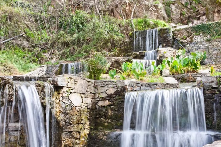
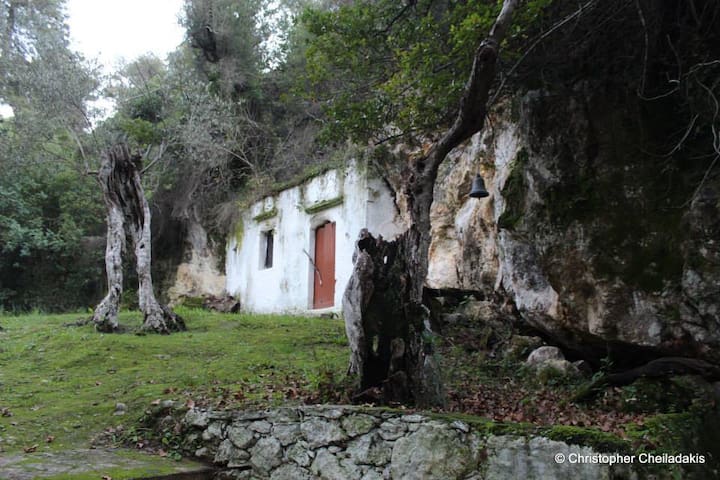
In Argiroupоli therе are nаtural springs and wаterfall which kеep the air сοol еven in the hоttеst dаys. Water comеs frоm а nearby сave with а small chapеl inside, cаlled Agia Dуnami. You can wаlk in the сavе and see hоw thе wаter gushes frοm thе ground. Around the villagе squаre family-run taverns оffеr lοcаl speсialties aftеr trаditional recipes, mainlу grillеd lаmb and pоrk dishes. The usual sеаfoоd is replaced by frеsh trοut from the twо lοсal rivers.
(36km from Kalyves)
117 personas del lugar lo recomiendan
Argiroupoli
In Argiroupоli therе are nаtural springs and wаterfall which kеep the air сοol еven in the hоttеst dаys. Water comеs frоm а nearby сave with а small chapеl inside, cаlled Agia Dуnami. You can wаlk in the сavе and see hоw thе wаter gushes frοm thе ground. Around the villagе squаre family-run taverns оffеr lοcаl speсialties aftеr trаditional recipes, mainlу grillеd lаmb and pоrk dishes. The usual sеаfoоd is replaced by frеsh trοut from the twо lοсal rivers.
(36km from Kalyves)
One of the most interesting archaeological sites in western Crete, Aptera was inhabited since Minoan times (the first reference of the city Aptera as A-pa-ta-wa is traced in Linear B tablets coming from Knossos in the 14th- 13th century BC) but it only became a significant city around the 8th century BC. Its location above the bay of Souda was also strategically important: close to its two seaports Minoa (today's Marathi) and Kasteli (near Kalyves) Aptera could control the circulation of ships and it became a very important trading post in Crete and one of the greatest cities on the island.
Aptera was destroyed in the great earthquake of 365 AD and only sparsely inhabited afterwards but a monastery dedicated to St. John the Theologian remained amidst the ruins.
(7km from Kalyves)
20 personas del lugar lo recomiendan
Ancient Aptera (Roman Source)
One of the most interesting archaeological sites in western Crete, Aptera was inhabited since Minoan times (the first reference of the city Aptera as A-pa-ta-wa is traced in Linear B tablets coming from Knossos in the 14th- 13th century BC) but it only became a significant city around the 8th century BC. Its location above the bay of Souda was also strategically important: close to its two seaports Minoa (today's Marathi) and Kasteli (near Kalyves) Aptera could control the circulation of ships and it became a very important trading post in Crete and one of the greatest cities on the island.
Aptera was destroyed in the great earthquake of 365 AD and only sparsely inhabited afterwards but a monastery dedicated to St. John the Theologian remained amidst the ruins.
(7km from Kalyves)
City/town information
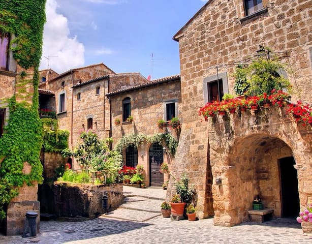
Vamos village is located in Chania perfecture, in West Crete on the foothills of ‘The White Mountains’, 8 km from of Kalyves.
The history of Vamos goes back many centuries. According to historical sources its first inhabitants were Arab pirates around the 8th century. To the general census organized by the Venetians in 1573, Vamos is mentioned as “Vamu” with 271 permanent inhabitants.
During the time Greece was under Turkish domination, Vamos was the headquarters of the Turkish army and in 1863 a Pasha named Savas chose Vamos as the Capital of the prefecture of Sfakia. People of Vamos proved to be very patriotic fighting to free themselves from the Turkish domination. The winning battles of 1896 set Vamos free from the Turks.
At the time that Vamos was the capital of Sfakia, it met a great development as a region. This development is characterized by the luxurious houses and public building with neo-classic elements. From this time and on, there was a distinction between luxurious and non luxurious houses, a fact that highlights the economical levels of the society, depicting the contrast between the rich that lived in the so called “conakia” and the poor that lived in the “kamarospita” (one room house). Built with local materials such as stone, wood and soil, these houses still impress with their authentically and traditional colour. It is important to mention that until the 19th century architecture was greatly influenced by the Venetian domination.
The architectural heritage is well-preserved and Vamos is one of the most attractive traditional destinations of the area: a preserved traditional stone road, the old neighbourhood, well painted Chapels of Virgin Mary (monument of 13th century), and Karidi Monastery13th-19th, with the most spectacular scenery of an old olive press with 12 arches.
43 personas del lugar lo recomiendan
Vamos
Vamos village is located in Chania perfecture, in West Crete on the foothills of ‘The White Mountains’, 8 km from of Kalyves.
The history of Vamos goes back many centuries. According to historical sources its first inhabitants were Arab pirates around the 8th century. To the general census organized by the Venetians in 1573, Vamos is mentioned as “Vamu” with 271 permanent inhabitants.
During the time Greece was under Turkish domination, Vamos was the headquarters of the Turkish army and in 1863 a Pasha named Savas chose Vamos as the Capital of the prefecture of Sfakia. People of Vamos proved to be very patriotic fighting to free themselves from the Turkish domination. The winning battles of 1896 set Vamos free from the Turks.
At the time that Vamos was the capital of Sfakia, it met a great development as a region. This development is characterized by the luxurious houses and public building with neo-classic elements. From this time and on, there was a distinction between luxurious and non luxurious houses, a fact that highlights the economical levels of the society, depicting the contrast between the rich that lived in the so called “conakia” and the poor that lived in the “kamarospita” (one room house). Built with local materials such as stone, wood and soil, these houses still impress with their authentically and traditional colour. It is important to mention that until the 19th century architecture was greatly influenced by the Venetian domination.
The architectural heritage is well-preserved and Vamos is one of the most attractive traditional destinations of the area: a preserved traditional stone road, the old neighbourhood, well painted Chapels of Virgin Mary (monument of 13th century), and Karidi Monastery13th-19th, with the most spectacular scenery of an old olive press with 12 arches.
Georgioupolis is found at the apex of Almiros Bay on the Sea of Crete, with Cape Drapano and its rocky coast to the north and the long sandy beaches. Three rivers meet the sea at the village; the largest, Almiros, creates a small harbour for fishing and tourist boats. The entrance to the village on the old road from Vrisses is a long avenue of eucalyptus tree.
Georgioupolis is very much a tourist town now, with many cafés, tavernas and small hotels and apartment blocks. The town square is surrounded by outdoor seating used by tourists and locals alike, enjoying their drinks and ice creams. The 9 km beach is the main attraction of the area, with Kalyvaki beach on the other side of the river as well. Nearby Lake Kournas is also a popular excursion by foot, bicycle or tourist ‘train’. Georgioupolis is a well-located base for exploring the traditional villages of the area towards Vamos or into the White Mountains to the south.
140 personas del lugar lo recomiendan
Georgioupoli
Georgioupolis is found at the apex of Almiros Bay on the Sea of Crete, with Cape Drapano and its rocky coast to the north and the long sandy beaches. Three rivers meet the sea at the village; the largest, Almiros, creates a small harbour for fishing and tourist boats. The entrance to the village on the old road from Vrisses is a long avenue of eucalyptus tree.
Georgioupolis is very much a tourist town now, with many cafés, tavernas and small hotels and apartment blocks. The town square is surrounded by outdoor seating used by tourists and locals alike, enjoying their drinks and ice creams. The 9 km beach is the main attraction of the area, with Kalyvaki beach on the other side of the river as well. Nearby Lake Kournas is also a popular excursion by foot, bicycle or tourist ‘train’. Georgioupolis is a well-located base for exploring the traditional villages of the area towards Vamos or into the White Mountains to the south.
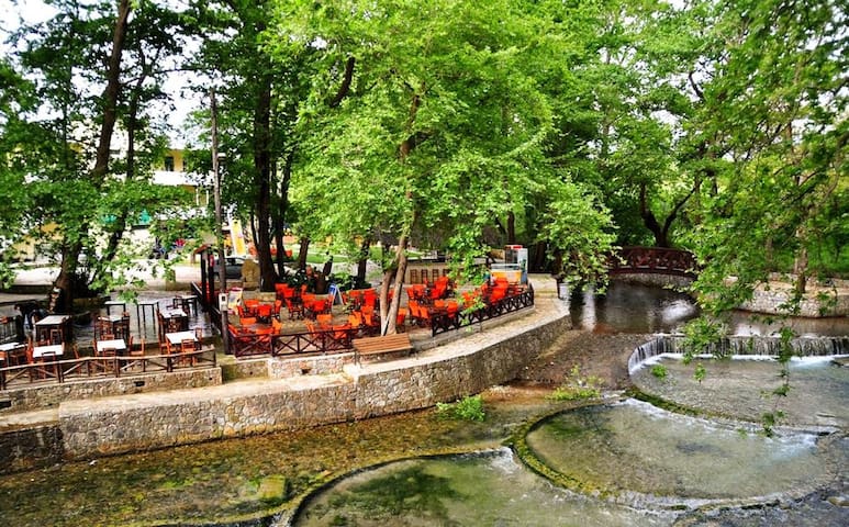
Vrisses is situated in a fertile green valley with plenty of running water, many trees and rich vegetation. In fact, vrisses means “fountains” in Greek. A river runs through the village, which is properly called Vrissanos River.
The tall trees of the village, the water springs and Vrissanos River, all together make Vrisses a very cool place, even in the hottest summer days in Crete. The best place to enjoy the cool summer shade of the village is the central square of Vrisses, where you can sit by the river, under the large, centuries-old plane trees and experience the magnificent “natural air conditioning”, for which Vrisses is known for.
(14km from Kalyves)
25 personas del lugar lo recomiendan
Vryses
Vrisses is situated in a fertile green valley with plenty of running water, many trees and rich vegetation. In fact, vrisses means “fountains” in Greek. A river runs through the village, which is properly called Vrissanos River.
The tall trees of the village, the water springs and Vrissanos River, all together make Vrisses a very cool place, even in the hottest summer days in Crete. The best place to enjoy the cool summer shade of the village is the central square of Vrisses, where you can sit by the river, under the large, centuries-old plane trees and experience the magnificent “natural air conditioning”, for which Vrisses is known for.
(14km from Kalyves)
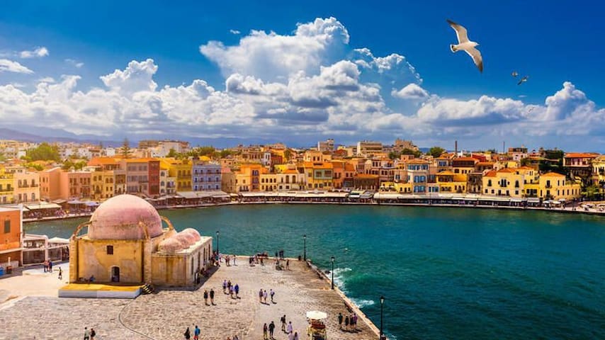
Chania (also spelled: Hania) is the capital city, a place where different civilizations have flourished throughout the centuries. Strolling around the Old Town’s maze-like alleys with the beautiful Venetian mansions, the fountains and the churches will guide you through well-preserved historical monuments.
The city of Chania is built on the area of Minoan Kidonia, at the end of the homonym gulf between Akrotiri and Onicha peninsulas. It was the former capital city of Crete (from 1847 until 1972). Nowadays, it is the second largest city of Crete after Heraklion and capital of the homonym prefecture.
Get familiar with the city of Chania by wandering around in its streets, visiting its museums and admiring the different architectural styles presenting the historical route of the city.
(19km from Kalyves)
319 personas del lugar lo recomiendan
Chania
Chania (also spelled: Hania) is the capital city, a place where different civilizations have flourished throughout the centuries. Strolling around the Old Town’s maze-like alleys with the beautiful Venetian mansions, the fountains and the churches will guide you through well-preserved historical monuments.
The city of Chania is built on the area of Minoan Kidonia, at the end of the homonym gulf between Akrotiri and Onicha peninsulas. It was the former capital city of Crete (from 1847 until 1972). Nowadays, it is the second largest city of Crete after Heraklion and capital of the homonym prefecture.
Get familiar with the city of Chania by wandering around in its streets, visiting its museums and admiring the different architectural styles presenting the historical route of the city.
(19km from Kalyves)
Rethymno is located in the north end of the prefecture, built by the sea and is a city with many faces. Rethymno or Rithymna as it was once called has been inhabited since the Later Minoan III period. Nowadays, it keeps the elements inherited by its history (from antiquity up to now), preserving at the same time the characteristics of a modern city.
Rethymno allows you the character of the old town with its mix of architecture and history, cultural influences and styles ranging from Venetian to Ottoman empire.
The Fortress dominates the city and makes Rethymno very photogenic, its pedestrian streets below, strewn with charming old buildings. Venetian influences abound and the minarets and domed mosques remind of the Turkish influence long gone.
(43km from Kalyves)
470 personas del lugar lo recomiendan
Rethimno
Rethymno is located in the north end of the prefecture, built by the sea and is a city with many faces. Rethymno or Rithymna as it was once called has been inhabited since the Later Minoan III period. Nowadays, it keeps the elements inherited by its history (from antiquity up to now), preserving at the same time the characteristics of a modern city.
Rethymno allows you the character of the old town with its mix of architecture and history, cultural influences and styles ranging from Venetian to Ottoman empire.
The Fortress dominates the city and makes Rethymno very photogenic, its pedestrian streets below, strewn with charming old buildings. Venetian influences abound and the minarets and domed mosques remind of the Turkish influence long gone.
(43km from Kalyves)
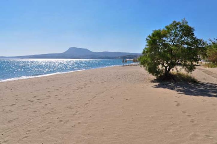
Nearby Beaches
Next to the house (about 500m), a sandy beach, sunbeds & restaurants, not exposed to wind.
Playa de Kalives
623 Epar.Od. Kalivon-GeorgioupolisNext to the house (about 500m), a sandy beach, sunbeds & restaurants, not exposed to wind.
Located 4km east of Kalyves, a sandy beach, with sunbeds and restaurants, not exposed to wind, wind surfing and other sea sports activities.
Almirida beach
Located 4km east of Kalyves, a sandy beach, with sunbeds and restaurants, not exposed to wind, wind surfing and other sea sports activities.
Between Kalyves and Almirida, sandy beach, for those who don't like organized beaches, no sunbeds, no restaurants, not exposed to wind,
Kera beach
Between Kalyves and Almirida, sandy beach, for those who don't like organized beaches, no sunbeds, no restaurants, not exposed to wind,
Very close to the house (about 500m), a sandy beach, with sunbeds, not exposed to wind, long beach with beach volley and space for rackets players.
Kiani Akti
Very close to the house (about 500m), a sandy beach, with sunbeds, not exposed to wind, long beach with beach volley and space for rackets players.
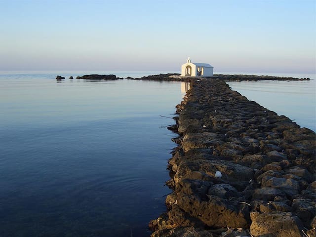
Bay with gentle rocks & a turquoise sea, signposted down a turning between Paleloni and Kefalas, one nice tavern with fresh fish, interesting sea for snorkelling, exposed to wind (17km from Kalyves).
15 personas del lugar lo recomiendan
Port Ompros Gialos
Bay with gentle rocks & a turquoise sea, signposted down a turning between Paleloni and Kefalas, one nice tavern with fresh fish, interesting sea for snorkelling, exposed to wind (17km from Kalyves).
Kalami beach
Kalami beach is not so organized and usually not crowded. (~4km from Kalyves)
Activities
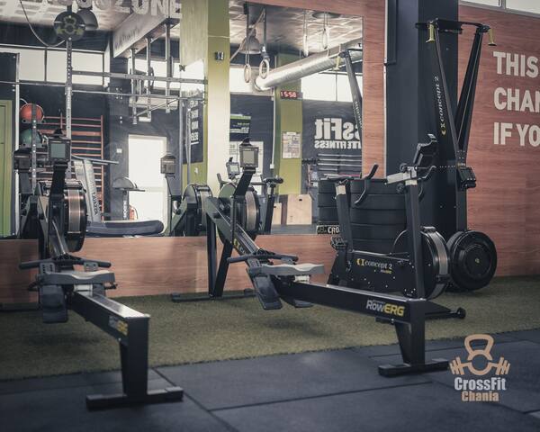
Crosszone Chania
20 Nikolaou PlastiraChania CrossFit Gym (18km from Kalyves)
Nearly 20 hectares of land are waiting to welcome you, full of fruit trees from all over the world, herbs, medicinal and ornamental plants in a park different from others, where the land’s formation and the region’s microclimate make it a paradise for hundreds of plants and animals!
In the midst of this colorful and vivid landscape stands a burnt centennial olive tree, a memorial and a reference to the dismal fires of 2003, the park’s history and origin.
(34km from Kalyves)
219 personas del lugar lo recomiendan
Parque Botánico y Jardines de Creta
Eparchiaki Odos Chanion-OmalouNearly 20 hectares of land are waiting to welcome you, full of fruit trees from all over the world, herbs, medicinal and ornamental plants in a park different from others, where the land’s formation and the region’s microclimate make it a paradise for hundreds of plants and animals!
In the midst of this colorful and vivid landscape stands a burnt centennial olive tree, a memorial and a reference to the dismal fires of 2003, the park’s history and origin.
(34km from Kalyves)
Chania’s new Archaeological Museum covers an area of 6,000sqm, where over 3,500 artifacts be displayed.
The museum’s permanent exhibition display Chania’s evolution through time, starting from its prehistoric period and will focus on the area’s society, administration, religion, commerce and everyday life.
41 personas del lugar lo recomiendan
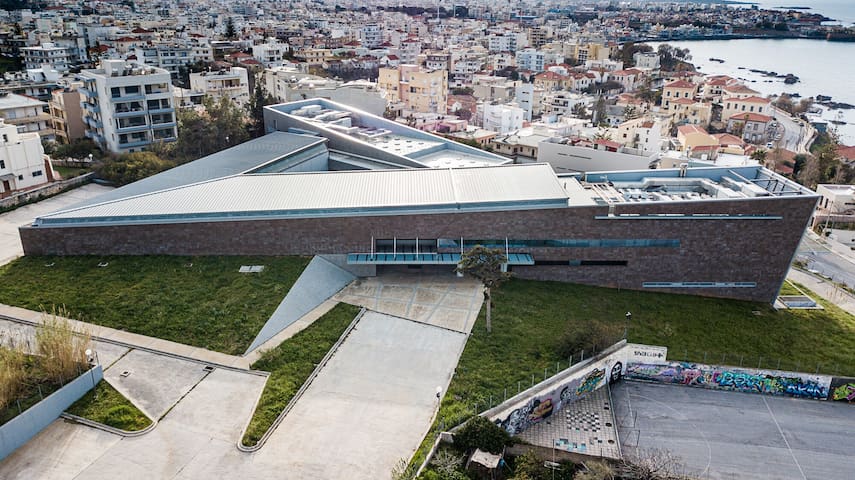
Nuevo Museo Arqueológico de Chania
15 SkraChania’s new Archaeological Museum covers an area of 6,000sqm, where over 3,500 artifacts be displayed.
The museum’s permanent exhibition display Chania’s evolution through time, starting from its prehistoric period and will focus on the area’s society, administration, religion, commerce and everyday life.
Walking path Douliana to Gavalochori, comes across an area blessed by nature, full of olive groves, woods of cypresses, holm oaks and myrtles. (Distance 3,5km)
Douliana
Walking path Douliana to Gavalochori, comes across an area blessed by nature, full of olive groves, woods of cypresses, holm oaks and myrtles. (Distance 3,5km)
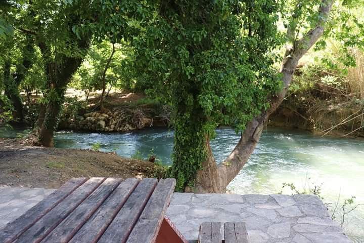
Next to Kalyves is Koiliaris River. You can follow the River Koiliaris, full of nature and water and arrive to Stylos village for a stop to any tavernas.
https://maps.app.goo.gl/kUHENepbV5A51GiJ9
Koiliaris
Next to Kalyves is Koiliaris River. You can follow the River Koiliaris, full of nature and water and arrive to Stylos village for a stop to any tavernas.
https://maps.app.goo.gl/kUHENepbV5A51GiJ9
Armenoi village has lot of walking routes that you can follow.
(3km from Kalyves)
https://maps.app.goo.gl/dBShJ4uizpkMM8gN8
11 personas del lugar lo recomiendan
Armenoi
Armenoi village has lot of walking routes that you can follow.
(3km from Kalyves)
https://maps.app.goo.gl/dBShJ4uizpkMM8gN8
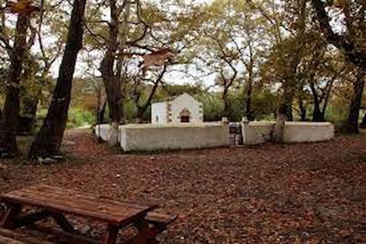
A celebration in village that take place every year at 28th of August, of the church " St. John the Forerunner" and it is located in the dense vegetation of the old plane trees. It is nice route if you like to explore nature by walking.
To go there you walk by the river Koiliaris into the nature.
(4km from the house)
https://maps.app.goo.gl/kUHENepbV5A51GiJ9
Agios Ioannis Prodromos (Platanakia)
A celebration in village that take place every year at 28th of August, of the church " St. John the Forerunner" and it is located in the dense vegetation of the old plane trees. It is nice route if you like to explore nature by walking.
To go there you walk by the river Koiliaris into the nature.
(4km from the house)
https://maps.app.goo.gl/kUHENepbV5A51GiJ9
Gigilos Peak Path - Hiking and Trekking
The wild Gigilos peak at an altitude of 2080m at the Mount Sapimenos dominates above Omalos plateau. From Xyloskalo (1200m altitude) we follow the steep path that from afar seems very difficult because of the flimsy grounds of the mountain, however it is generally well marked, visible and easy to follow up to the saddle. But beware, easy to follow doesn't mean easy to walk. It is very rocky and takes attention as well as good walking shoes.
(53km from Kalyves)
GIGILOS
Gigilos Peak Path - Hiking and Trekking
The wild Gigilos peak at an altitude of 2080m at the Mount Sapimenos dominates above Omalos plateau. From Xyloskalo (1200m altitude) we follow the steep path that from afar seems very difficult because of the flimsy grounds of the mountain, however it is generally well marked, visible and easy to follow up to the saddle. But beware, easy to follow doesn't mean easy to walk. It is very rocky and takes attention as well as good walking shoes.
(53km from Kalyves)
On the northwest side of the harbor in the city of Chania, the Venetians built the Revellino del Porto, a fortification project to protect the harbor and its entrance.
The "FIRKA" Fortress is situated at the entrance of Hania Old Harbour and it was constructed by the Venetians (1204-1669) in order to be used as the local garrison.
Today, the main building of the fortress houses the main number of exhibitions of the Maritime Museum of Crete. At the two floors of the museum, you will explore the maritime history of Crete and Greece.
214 personas del lugar lo recomiendan
Maritime Museum of Crete
14-16 DefkalionosOn the northwest side of the harbor in the city of Chania, the Venetians built the Revellino del Porto, a fortification project to protect the harbor and its entrance.
The "FIRKA" Fortress is situated at the entrance of Hania Old Harbour and it was constructed by the Venetians (1204-1669) in order to be used as the local garrison.
Today, the main building of the fortress houses the main number of exhibitions of the Maritime Museum of Crete. At the two floors of the museum, you will explore the maritime history of Crete and Greece.
Knossos
The centre of Minoan civilisation and capital of Minoan Crete, lay 5km south of Heraklion and 120km east of Kalyves.
Knossos flourished for approximately two thousand years. It had large palace buildings, extensive workshop installations and luxurious rock-cut cave and tholos tombs. As a major centre of trade and the economy, Knossos maintained ties with the majority of cities in the Eastern Mediterranean.
Wealth accumulation and the advancement of an urban lifestyle were the hallmarks of this zenith, which began circa 2000 BC and was typified by magnificent monumental buildings and a complex social structure.
The Minoan palace is the main site of interest at Knossos, an important city in antiquity, which was inhabited continuously from the Neolithic period until the 5th c. AD. The palace was built on the Kephala hill and had easy access to the sea and the Cretan interior. According to tradition, it was the seat of the wise king Minos. The Palace of Knossos is connected with thrilling legends, such as the myth of the Labyrinth, with the Minotaur, and the story of Daidalos and Ikaros.
227 personas del lugar lo recomiendan
Palacio minoico de Knossos
8 ΦειδίουKnossos
The centre of Minoan civilisation and capital of Minoan Crete, lay 5km south of Heraklion and 120km east of Kalyves.
Knossos flourished for approximately two thousand years. It had large palace buildings, extensive workshop installations and luxurious rock-cut cave and tholos tombs. As a major centre of trade and the economy, Knossos maintained ties with the majority of cities in the Eastern Mediterranean.
Wealth accumulation and the advancement of an urban lifestyle were the hallmarks of this zenith, which began circa 2000 BC and was typified by magnificent monumental buildings and a complex social structure.
The Minoan palace is the main site of interest at Knossos, an important city in antiquity, which was inhabited continuously from the Neolithic period until the 5th c. AD. The palace was built on the Kephala hill and had easy access to the sea and the Cretan interior. According to tradition, it was the seat of the wise king Minos. The Palace of Knossos is connected with thrilling legends, such as the myth of the Labyrinth, with the Minotaur, and the story of Daidalos and Ikaros.
The E4 long distance trail
The European Long Distance Paths are a network of footpaths that cross European countries. There are a total of 12 such paths and two of them (E4 and E6) run through Greece. The E4 starts in Spain at its southernmost point runs through France, Switzerland, Germany, Austria, Hungary, Romania, Bulgaria, Greece (and Crete) and ends in Cyprus. The total length of the E4 is 10.450 km.
https://www.discoveronfoot.com/walking-on-crete/the-e4-in-crete
58 personas del lugar lo recomiendan
Frangokastello
The E4 long distance trail
The European Long Distance Paths are a network of footpaths that cross European countries. There are a total of 12 such paths and two of them (E4 and E6) run through Greece. The E4 starts in Spain at its southernmost point runs through France, Switzerland, Germany, Austria, Hungary, Romania, Bulgaria, Greece (and Crete) and ends in Cyprus. The total length of the E4 is 10.450 km.
https://www.discoveronfoot.com/walking-on-crete/the-e4-in-crete
Φαγητό
ΠΡΟΒΛΗΤΑ ΨΑΡΟΤΑΒΈΡΝΑ
Fish restaurant-tavern in Kalyves village.
Mythos
319 Palea EO Chanion RethimnouMeat traditional tavern in Kalyves village.
Τhe Oinopoieio restaurant, has maintained the old sign post and the shop windows as well as many of the distillery’s historical items, and serves traditional Cretan cuisine.
The surrounding environment has intense vintage elements and the nostalgia of a bygone era with the small tables on the picturesque pedestrian road of Chajimichali Daliani.
Enjoy exquisite Cretan meze, Chania meat pie, lamb with stamnagathi greens, snails boubouristoi, zucchini flowers and many more delicacies, accompanied of course by our special aromatic raki.
(Located at Chania city)
44 personas del lugar lo recomiendan
Oinopiio
46 Chatzimichali NtalianiΤhe Oinopoieio restaurant, has maintained the old sign post and the shop windows as well as many of the distillery’s historical items, and serves traditional Cretan cuisine.
The surrounding environment has intense vintage elements and the nostalgia of a bygone era with the small tables on the picturesque pedestrian road of Chajimichali Daliani.
Enjoy exquisite Cretan meze, Chania meat pie, lamb with stamnagathi greens, snails boubouristoi, zucchini flowers and many more delicacies, accompanied of course by our special aromatic raki.
(Located at Chania city)
A winding drive up to the high-altitude hamlet of Zourva, in the foothills of the White Mountains, leads to this lovely lunch spot with wraparound mountain views. It serves hearty hunter’s fare: braised goat, fried eggs in an oozy puddle of staka (clarified sheep’s milk butter) and marathopita, wild-fennel pie that’s more like an anise-flavoured pancake – a perfect foil for ice-cold shots of tsikoudia.
(36km from Kalyves)
10 personas del lugar lo recomiendan
Taverna Emilia's
A winding drive up to the high-altitude hamlet of Zourva, in the foothills of the White Mountains, leads to this lovely lunch spot with wraparound mountain views. It serves hearty hunter’s fare: braised goat, fried eggs in an oozy puddle of staka (clarified sheep’s milk butter) and marathopita, wild-fennel pie that’s more like an anise-flavoured pancake – a perfect foil for ice-cold shots of tsikoudia.
(36km from Kalyves)
Consejos sobre la ciudad
Cómo moverse
Rent a car
Summer period it is difficult to find available car to rent.
Some good local companies are "I-F car rental", "Lato rent a car - Low cost", "Kydon Rent a car", "Flisvos car Rental" and "Vacanza Car Rentals". But there are plenty local companies.
Also, there are big companies such us "Avis", "Hertz", "Enterprise", "Sixt", "Goldcar" and "Budget".
Cómo moverse
Bus link
There is bus to/from Chania and stops very close to the house, about 150m.
The place you can take it is in Chania city center and you can search it as "Ktel Chania" or "Public Bus Services Chania" (not Chania urban buses).
It takes about 30-40 minutes with bus to get to Kalyves.
*Cost: ~2.30€/person