
Explore beautiful Lethbridge and amazing places in Southern Alberta
Sightseeing
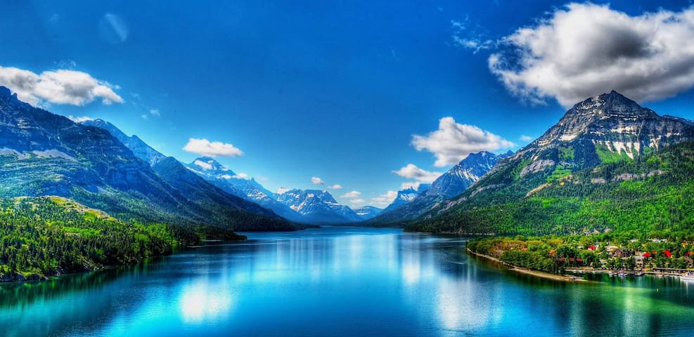
Hour and a half drive from Lethbridge to the beautiful Waterton Lakes National Park. Amazing place for all age groups to enjoy the core town, boating, hiking, biking, enjoying, dining and shopping.
There are places on earth that practically defy description – places so unique and so uniquely beautiful that you can’t quite find the words to express what your senses are taking in when you’re there. They are breathtaking to the eyes, to be sure, but the appeal of these places is somewhat intangible. It’s a feeling in the air, a vibe, an energy. You feel good just being there, and the more you explore your surroundings, the stronger the feeling becomes.
Waterton is one of those places. Nestled in the far southwest corner of Alberta, Waterton is one of the most distinctive mountain parks on the planet. Shaped over centuries by wind, fire, glacial ice and floods, the park’s ecosystem is so distinctive that it was designated a Biosphere Reserve by the United Nations. It boasts the title of International Peace Park too, thanks to the unguarded border it shares with Glacier National Park in Montana. And the activities? Well – those are otherworldly too.
The drive into Waterton is a journey of contrasts. Prairie magically gives way to rolling foothills, and suddenly the landscape transforms, expanding into a majestic display of rugged wilderness, the likes of which harken back to a time when nature was truly unspoiled.
Waterton was declared a National Park in 1895, and quite truthfully, not a tremendous amount has changed since then. Waterton is very much the sort of place you envision when imagining a quaint and rustic mountain town. The pace is rambling, there is no pretence to any of it, and the major attraction in the park is the great outdoors.
Nature thrives here. Waterton is home to more than 60 species of mammals, 250 species of birds, 24 species of fish and 10 species of reptiles and amphibians. More than half of Alberta’s plant species are found in Waterton and the park is home to a menagerie of impressive mountain creatures. Grizzly bear, black bear, wolf, coyote and cougar can all be found here.
The uniqueness of Waterton has been recognized in a number of ways. It was designated an International Peace Park due to the open border it shares with Glacier National Park to the south in Montana, and also a World Heritage Site, thanks to Waterton’s extraordinary ecosystem. The park is unusually diverse in its physical, biological and cultural resources. It’s also one of the narrowest places in the Rocky Mountain chain and has some of the oldest exposed sedimentary rock in the region.
The hiking here is legendary and it’s difficult to imagine a more majestic setting for a game of golf. Photographers, birdwatchers and botanists gather here for good reason. Waterton Lake is a wind surfer’s paradise and a fisherman’s dream. Campsites abound and cozy indoor accommodations dot the town site. There are numerous adventure companies standing at the ready, but if you’d rather wind things down, consider a picturesque picnic, a moonlight lake cruise, or quiet contemplation by Cameron Falls.
You name it, Waterton has it, and it has it the way mountain park aficionados love it best – unspoiled, uncrowded, and unbelievably beautiful.
The history of Waterton Lakes National Park is as deep and rich as its natural beauty.
The history of Waterton Lakes National Park is as deep and rich as its natural beauty. Its story begins more than 10,000 years ago when alpine glaciers melted out of the main valleys, making way for the first signs of human habitation.
For thousands of years nomadic tribes camped, hunted and gathered plants along the Waterton Lakes and river in relative harmony. The introduction of horses and guns in the 1700's changed their relationship to the land and to each other.
European expeditions in western Canada led to an altogether new perspective on this area. In 1858 Lt. Thomas Blakiston, originally a member of the Palliser Expedition, embarked on an expedition of his own looking for a railway pass through the mountains. On his journey, he encountered members of the Kutenai tribe who told him of the South Kootenay Pass. Taking their advice, Blakiston re-crossed the divide, traveling along what would later be called Blakiston (Pass) Creek and out to a chain of three large lakes.
On September 6, 1858, he wrote:
"After two hours traveling on level ground along Red-stone creek (Red-Rock) we emerged on the Saskatchewan plains, just six geographical miles north of the 49th parallel and camped at the lakes...
The scenery here is grand and picturesque...."
Blakiston named the lakes "Waterton", after British naturalist Charles Waterton, although the locals continued to call them Kootenay Lakes for many years after.
Other trailblazers exploring the area at that time were British and American surveying parties sent to mark the International Boundary established by the Oregon Treaty in 1846. In 1874, they reached Waterton, but found working in the mountains so difficult that they managed to erect only two markers in the area. Today, these markers represent the longest undefended border in the world. Visitors to Upper Waterton Lake still marvel at the line, a 20 foot cleared swath through the forests and across the mountains.
An Order in Council in 1895 to protect Waterton as a unique forest park set in motion a series of events that would eventually lead to its National Park status in 1930. John George 'Kootenai' Brown, Waterton's first park official, and American ranger Henry 'Death on the Trail' Reynolds (of Goat Haunt Montana) were the first to propose the idea of creating an International Peace Park with Glacier Park in Montana. As the parks shared the same geology, climate, wildlife and ecology, both Brown and Reynolds felt strongly that the lake and valley could not and should not be divided.
Reynolds wrote "the Geology recognizes no boundaries, and as the lake lay ... no man-made boundary could cleve the waters apart." Kootenai Brown agreed, saying, "it seems advisable to greatly enlarge this park ... it might be well to have a preserve and breeding grounds in conjunction with the United States Glacier Park."
The seeds for an International Peace Park were thus planted and taken a step further by the Cardston Rotary Club, who initiated a meeting of several regional clubs from Alberta and Montana. This first "annual goodwill meeting" convened in 1931 at the Prince of Wales Hotel, where the idea of establishing an International Peace Park in the Waterton/Glacier area was unanimously endorsed.
In 1932, Waterton Lakes National Park in Canada and the United States Glacier National Park united to form the world's first International Peace Park. On June 18, 1932, this partnership was dedicated to world peace by Sir Charles Arthur Mander on behalf of Rotary International. Today, this park continues to symbolize the bonds of peace and friendship between the people of the United States and Canada.
Several different ecological regions meet in Waterton - with prairie plants of the Great Plains, Rocky Mountain plants from northern areas, and coastal plants from the Pacific Northwest all overlapping. This means Waterton has an unusually rich and varied number of plants for its size; many of them are rare or threatened. More than half of Alberta's plant species can be found in Waterton. For this reason, Waterton Lakes National Park was designated a biosphere reserve as part of UNESCO's Man and the Biosphere Programme in 1979. Waterton was the first Canadian national park to receive this designation, the core zone covering the entire national park area.
On December 6, 1995, Waterton-Glacier International Peace Park was officially designated a UNESCO World Heritage Site, recognising its significance in ecological diversity and its model of cooperation and good will, not as two separate parks, but as one.
Waterton is a global treasure that enjoys a unique, triple distinction:
International Peace Park
UNESCO World Heritage Site
UNESCO Biosphere Reserve
Today Waterton remains a spectacular natural wonder - a blend of unusual geology, mild climate, rare wild flowers and an abundance of wildlife. Waterton offers an "all natural" experience like no other place in the world.
This is due in large part to the people who live here that have worked to preserve and maintain its magnificence. We are passionate about our community, our wildlife and the glorious mountains and vegetation that surround us.
If the heart of Waterton Lakes National Park is its rugged natural beauty, then Waterton Village is its pulse. This tiny, vibrant town site is an epicenter of activity, full of fun possibilities, great accommodations, necessary conveniences, and dining experiences that run the gamut from casual to white linen.
The best part? Waterton is decidedly low key – and despite the park’s popularity, you’ll never have to fight crowds while wandering the streets. Somehow or other, Waterton has managed to maintain its authenticity and its exclusivity. This is a truly natural mountain municipality – the very kind of place you envision when conjuring up ideas of an unspoiled mountain town. It’s rustic, it’s friendly, and it offers everything a visitor may want or need, whether staying for a few hours or a few days.
Where the mountains meet the prairie, Waterton Lakes National Park is 505 square kilometres (195 square miles) of wilderness mountain and lake landscapes surrounding the town of Waterton.
109 personas del lugar lo recomiendan
Parque Nacional de los Lagos Waterton
Alberta 5Hour and a half drive from Lethbridge to the beautiful Waterton Lakes National Park. Amazing place for all age groups to enjoy the core town, boating, hiking, biking, enjoying, dining and shopping.
There are places on earth that practically defy description – places so unique and so uniquely beautiful that you can’t quite find the words to express what your senses are taking in when you’re there. They are breathtaking to the eyes, to be sure, but the appeal of these places is somewhat intangible. It’s a feeling in the air, a vibe, an energy. You feel good just being there, and the more you explore your surroundings, the stronger the feeling becomes.
Waterton is one of those places. Nestled in the far southwest corner of Alberta, Waterton is one of the most distinctive mountain parks on the planet. Shaped over centuries by wind, fire, glacial ice and floods, the park’s ecosystem is so distinctive that it was designated a Biosphere Reserve by the United Nations. It boasts the title of International Peace Park too, thanks to the unguarded border it shares with Glacier National Park in Montana. And the activities? Well – those are otherworldly too.
The drive into Waterton is a journey of contrasts. Prairie magically gives way to rolling foothills, and suddenly the landscape transforms, expanding into a majestic display of rugged wilderness, the likes of which harken back to a time when nature was truly unspoiled.
Waterton was declared a National Park in 1895, and quite truthfully, not a tremendous amount has changed since then. Waterton is very much the sort of place you envision when imagining a quaint and rustic mountain town. The pace is rambling, there is no pretence to any of it, and the major attraction in the park is the great outdoors.
Nature thrives here. Waterton is home to more than 60 species of mammals, 250 species of birds, 24 species of fish and 10 species of reptiles and amphibians. More than half of Alberta’s plant species are found in Waterton and the park is home to a menagerie of impressive mountain creatures. Grizzly bear, black bear, wolf, coyote and cougar can all be found here.
The uniqueness of Waterton has been recognized in a number of ways. It was designated an International Peace Park due to the open border it shares with Glacier National Park to the south in Montana, and also a World Heritage Site, thanks to Waterton’s extraordinary ecosystem. The park is unusually diverse in its physical, biological and cultural resources. It’s also one of the narrowest places in the Rocky Mountain chain and has some of the oldest exposed sedimentary rock in the region.
The hiking here is legendary and it’s difficult to imagine a more majestic setting for a game of golf. Photographers, birdwatchers and botanists gather here for good reason. Waterton Lake is a wind surfer’s paradise and a fisherman’s dream. Campsites abound and cozy indoor accommodations dot the town site. There are numerous adventure companies standing at the ready, but if you’d rather wind things down, consider a picturesque picnic, a moonlight lake cruise, or quiet contemplation by Cameron Falls.
You name it, Waterton has it, and it has it the way mountain park aficionados love it best – unspoiled, uncrowded, and unbelievably beautiful.
The history of Waterton Lakes National Park is as deep and rich as its natural beauty.
The history of Waterton Lakes National Park is as deep and rich as its natural beauty. Its story begins more than 10,000 years ago when alpine glaciers melted out of the main valleys, making way for the first signs of human habitation.
For thousands of years nomadic tribes camped, hunted and gathered plants along the Waterton Lakes and river in relative harmony. The introduction of horses and guns in the 1700's changed their relationship to the land and to each other.
European expeditions in western Canada led to an altogether new perspective on this area. In 1858 Lt. Thomas Blakiston, originally a member of the Palliser Expedition, embarked on an expedition of his own looking for a railway pass through the mountains. On his journey, he encountered members of the Kutenai tribe who told him of the South Kootenay Pass. Taking their advice, Blakiston re-crossed the divide, traveling along what would later be called Blakiston (Pass) Creek and out to a chain of three large lakes.
On September 6, 1858, he wrote:
"After two hours traveling on level ground along Red-stone creek (Red-Rock) we emerged on the Saskatchewan plains, just six geographical miles north of the 49th parallel and camped at the lakes...
The scenery here is grand and picturesque...."
Blakiston named the lakes "Waterton", after British naturalist Charles Waterton, although the locals continued to call them Kootenay Lakes for many years after.
Other trailblazers exploring the area at that time were British and American surveying parties sent to mark the International Boundary established by the Oregon Treaty in 1846. In 1874, they reached Waterton, but found working in the mountains so difficult that they managed to erect only two markers in the area. Today, these markers represent the longest undefended border in the world. Visitors to Upper Waterton Lake still marvel at the line, a 20 foot cleared swath through the forests and across the mountains.
An Order in Council in 1895 to protect Waterton as a unique forest park set in motion a series of events that would eventually lead to its National Park status in 1930. John George 'Kootenai' Brown, Waterton's first park official, and American ranger Henry 'Death on the Trail' Reynolds (of Goat Haunt Montana) were the first to propose the idea of creating an International Peace Park with Glacier Park in Montana. As the parks shared the same geology, climate, wildlife and ecology, both Brown and Reynolds felt strongly that the lake and valley could not and should not be divided.
Reynolds wrote "the Geology recognizes no boundaries, and as the lake lay ... no man-made boundary could cleve the waters apart." Kootenai Brown agreed, saying, "it seems advisable to greatly enlarge this park ... it might be well to have a preserve and breeding grounds in conjunction with the United States Glacier Park."
The seeds for an International Peace Park were thus planted and taken a step further by the Cardston Rotary Club, who initiated a meeting of several regional clubs from Alberta and Montana. This first "annual goodwill meeting" convened in 1931 at the Prince of Wales Hotel, where the idea of establishing an International Peace Park in the Waterton/Glacier area was unanimously endorsed.
In 1932, Waterton Lakes National Park in Canada and the United States Glacier National Park united to form the world's first International Peace Park. On June 18, 1932, this partnership was dedicated to world peace by Sir Charles Arthur Mander on behalf of Rotary International. Today, this park continues to symbolize the bonds of peace and friendship between the people of the United States and Canada.
Several different ecological regions meet in Waterton - with prairie plants of the Great Plains, Rocky Mountain plants from northern areas, and coastal plants from the Pacific Northwest all overlapping. This means Waterton has an unusually rich and varied number of plants for its size; many of them are rare or threatened. More than half of Alberta's plant species can be found in Waterton. For this reason, Waterton Lakes National Park was designated a biosphere reserve as part of UNESCO's Man and the Biosphere Programme in 1979. Waterton was the first Canadian national park to receive this designation, the core zone covering the entire national park area.
On December 6, 1995, Waterton-Glacier International Peace Park was officially designated a UNESCO World Heritage Site, recognising its significance in ecological diversity and its model of cooperation and good will, not as two separate parks, but as one.
Waterton is a global treasure that enjoys a unique, triple distinction:
International Peace Park
UNESCO World Heritage Site
UNESCO Biosphere Reserve
Today Waterton remains a spectacular natural wonder - a blend of unusual geology, mild climate, rare wild flowers and an abundance of wildlife. Waterton offers an "all natural" experience like no other place in the world.
This is due in large part to the people who live here that have worked to preserve and maintain its magnificence. We are passionate about our community, our wildlife and the glorious mountains and vegetation that surround us.
If the heart of Waterton Lakes National Park is its rugged natural beauty, then Waterton Village is its pulse. This tiny, vibrant town site is an epicenter of activity, full of fun possibilities, great accommodations, necessary conveniences, and dining experiences that run the gamut from casual to white linen.
The best part? Waterton is decidedly low key – and despite the park’s popularity, you’ll never have to fight crowds while wandering the streets. Somehow or other, Waterton has managed to maintain its authenticity and its exclusivity. This is a truly natural mountain municipality – the very kind of place you envision when conjuring up ideas of an unspoiled mountain town. It’s rustic, it’s friendly, and it offers everything a visitor may want or need, whether staying for a few hours or a few days.
Where the mountains meet the prairie, Waterton Lakes National Park is 505 square kilometres (195 square miles) of wilderness mountain and lake landscapes surrounding the town of Waterton.
Photographers love to take pictures of this iconic bridge at various times of the day especially when trains are crossing the bridge or natural sunlight in the background at different times of the day.
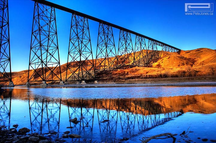
Lethbridge High Level Bridge
Scenic Drive SouthPhotographers love to take pictures of this iconic bridge at various times of the day especially when trains are crossing the bridge or natural sunlight in the background at different times of the day.
If you have dog, this is our favorite location where you can enjoy the walk in the coulees while your dog enjoys the off leash adventure in the nature.
Scenic Drive Dog Run
1107 6 St SIf you have dog, this is our favorite location where you can enjoy the walk in the coulees while your dog enjoys the off leash adventure in the nature.
Plan a day to walk around the Henderson Lake followed by various events at the Japanese garden with children. Driving to the park is easy and ample free parking is available. It is also a good spot to take pictures and create beautiful memories in Lethbridge.
19 personas del lugar lo recomiendan
Henderson Lake
Plan a day to walk around the Henderson Lake followed by various events at the Japanese garden with children. Driving to the park is easy and ample free parking is available. It is also a good spot to take pictures and create beautiful memories in Lethbridge.
Learn about amazing nature and the gifts it has to offer. Perfect place to explore the walking trails and a quiet boating experience in the Milk River.
18 personas del lugar lo recomiendan
Helen Schuler Nature Centre
300 Indian Battle Rd SLearn about amazing nature and the gifts it has to offer. Perfect place to explore the walking trails and a quiet boating experience in the Milk River.
Fort Whoop-Up is a replica of an original fur trading fort built in the late 1800s. It tells the story of the buffalo robe and illegal whisky trade, the years leading up to and the years that followed. It also tells the story of this region and the people here from the mid-1860s to the early 1890s. It is a complex story that includes the Niitsitapi (Blackfoot), other First Nations, Métis, Canadians, Americans, and British.
20 personas del lugar lo recomiendan
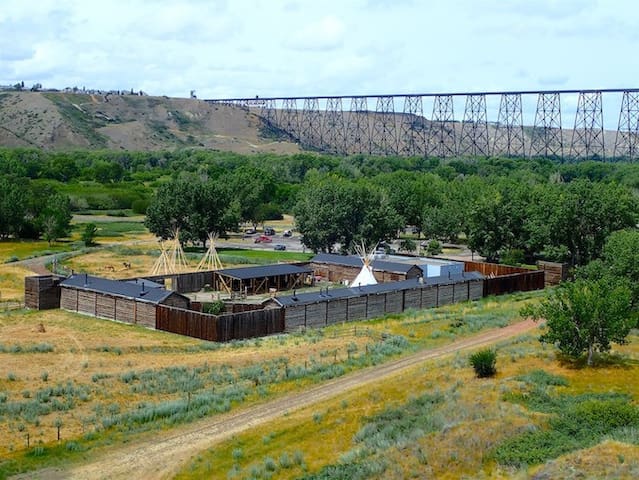
Fort Whoop-Up
200 Indian Battle Rd SFort Whoop-Up is a replica of an original fur trading fort built in the late 1800s. It tells the story of the buffalo robe and illegal whisky trade, the years leading up to and the years that followed. It also tells the story of this region and the people here from the mid-1860s to the early 1890s. It is a complex story that includes the Niitsitapi (Blackfoot), other First Nations, Métis, Canadians, Americans, and British.
The regional museum for southern Alberta. Located in Lethbridge, the Galt provides historical information on the human history of the area from Blackfoot culture, to coal mining, to regional breweries; there is something here for everyone.
The Galt is well respected in Alberta's museum community, has a growing national profile and is committed to international museum standards. The archives contain an extensive collection of information on the human history of Lethbridge and southwestern Alberta. Today, the museum cares for well over 17,000 artifacts and more than 1 million archival documents and photographs. These collections continue to grow.
The history of Lethbridge and southwestern Alberta can be explored through the Galt's rotating world-class exhibits, special events, and school and community programs. The Galt Museum Store offers visitors a selection of historic publications and other unique local and retro gifts. Volunteers donate their time and talents to enhance the work of museum staff.
In addition to numerous walking trails and interpretive signage, the Museum Grounds include two gardens created in partnership with two community groups: The Lethbridge & District Horticultural Society and the Galt School of Nursing Alumnae Association. The South Garden is made possible by additional community support.
The Lethbridge & District Horticultural Society began planting a Garden of Native Prairie Plants containing over 40 species of native plants in September 2008 to be ready for its 2009 Centennial Celebration. Designed by Lethbridge-based horticulturalist June Flanagan, it is appealing in all four seasons and features:
a variety of wildflowers, grasses and woody plants
attractive flowers through the growing season
autumn leaf colour, seed heads, fruit and interesting bark
The plants are placed similar to how they would grow in the river valley: shade tolerant species on the slope against the north wall of the museum, the most drought tolerant species on the steep, southwest-facing slope. Galt volunteers collect, clean and package the seeds, and they are available in the Galt Museum Store.
From the earliest times, people have sought out plants for medicinal purposes. Perhaps less spiritual, but no less inquisitive and experimental, gardeners and gatherers from across the ages have dedicated much of their lives to finding plants that could be used for food, clothing, shelter and ornament. Certainly, nomadic people depended on the plants they could find in order to sustain themselves. Over the past twenty-five thousand years, the First Nations people of the prairie developed a knowledge and understanding of the local plants that could help or harm them.
The historical relationship between First Nations people and the plants they used was complex. Dr. Alex Johnston reports that the Blackfoot knew and used about one hundred eighty-five species of plants for purposes of “religion and ceremony, crafts and folklore, birth control, medicines, horse medicines and diet.” Many of these plants can be found in The Garden of Native Prairie Plants, created to commemorate the centenary of the Lethbridge and District Horticultural Society, on the grounds surrounding the Galt Museum & Archives.
24 personas del lugar lo recomiendan
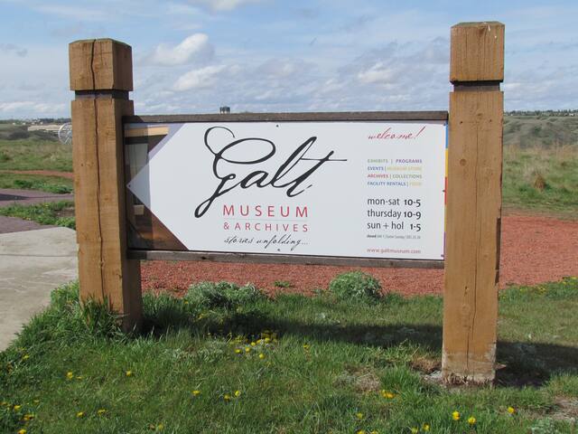
Galt Museum & Archives
502 1 St SThe regional museum for southern Alberta. Located in Lethbridge, the Galt provides historical information on the human history of the area from Blackfoot culture, to coal mining, to regional breweries; there is something here for everyone.
The Galt is well respected in Alberta's museum community, has a growing national profile and is committed to international museum standards. The archives contain an extensive collection of information on the human history of Lethbridge and southwestern Alberta. Today, the museum cares for well over 17,000 artifacts and more than 1 million archival documents and photographs. These collections continue to grow.
The history of Lethbridge and southwestern Alberta can be explored through the Galt's rotating world-class exhibits, special events, and school and community programs. The Galt Museum Store offers visitors a selection of historic publications and other unique local and retro gifts. Volunteers donate their time and talents to enhance the work of museum staff.
In addition to numerous walking trails and interpretive signage, the Museum Grounds include two gardens created in partnership with two community groups: The Lethbridge & District Horticultural Society and the Galt School of Nursing Alumnae Association. The South Garden is made possible by additional community support.
The Lethbridge & District Horticultural Society began planting a Garden of Native Prairie Plants containing over 40 species of native plants in September 2008 to be ready for its 2009 Centennial Celebration. Designed by Lethbridge-based horticulturalist June Flanagan, it is appealing in all four seasons and features:
a variety of wildflowers, grasses and woody plants
attractive flowers through the growing season
autumn leaf colour, seed heads, fruit and interesting bark
The plants are placed similar to how they would grow in the river valley: shade tolerant species on the slope against the north wall of the museum, the most drought tolerant species on the steep, southwest-facing slope. Galt volunteers collect, clean and package the seeds, and they are available in the Galt Museum Store.
From the earliest times, people have sought out plants for medicinal purposes. Perhaps less spiritual, but no less inquisitive and experimental, gardeners and gatherers from across the ages have dedicated much of their lives to finding plants that could be used for food, clothing, shelter and ornament. Certainly, nomadic people depended on the plants they could find in order to sustain themselves. Over the past twenty-five thousand years, the First Nations people of the prairie developed a knowledge and understanding of the local plants that could help or harm them.
The historical relationship between First Nations people and the plants they used was complex. Dr. Alex Johnston reports that the Blackfoot knew and used about one hundred eighty-five species of plants for purposes of “religion and ceremony, crafts and folklore, birth control, medicines, horse medicines and diet.” Many of these plants can be found in The Garden of Native Prairie Plants, created to commemorate the centenary of the Lethbridge and District Horticultural Society, on the grounds surrounding the Galt Museum & Archives.
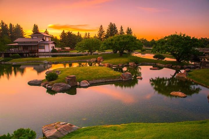
The Nikka Yuko Japanese Garden offers you an unforgettable cultural experience, combining the beauty of nature in a serene setting. From the first spring blossom to the final autumn leaf, the Garden is an oasis of tranquility.
Established during Canada’s Centennial in 1967, Nikka Yuko was built to recognize contributions made by citizens of Japanese ancestry to the multi-cultural community of Lethbridge, Alberta, and as a symbol of international friendship. Its name was created from the Japanese words Ni (from Nihon meaning Japan), ka from Kanada or Canada, and Yuko, which translates as "friendship" to mean “Japan-Canada friendship”.
The idea for Nikka Yuko began with a small group of people: Reverend Yutetsu Kawamura, a Canadian Buddhist priest, his wife Yoneko, and Cleo Mowers, publisher of the Lethbridge Herald. Their vision was to create a Japanese-style garden that reflected the magnificent mountain and prairie scenery of southern Alberta. In Japanese garden design philosophy, nature is interpreted through abstract and artistic symbolism, which results in a very intriguing landscape. When Kurt Steiner, the manager of the city tourism organization, heard the idea, he immediately promoted it, and the surrounding community came together to champion a unique event in a small Canadian city.
From the beginning, it was agreed that the garden must be authentic and of the highest quality, therefore, respected Japanese garden designer and landscape architect Tadashi Kubo, of Osaka Prefecture University was commissioned to design it. A Japanese garden not only reflects the local natural landscape, but also the culture. Kubo embarked on an intensive study of the land, its people and their way of life, determining how the garden would be used, before submitting the master plan. His colleague, Masami Sugimoto, also of Osaka Prefecture University, oversaw the construction, evaluating and adjusting each detail on site until every aspect of the garden was harmoniously balanced.
As a result, Nikka Yuko expresses the merging of Japanese and Canadian culture in a garden rich in symbolism. It captures the signature of the southern Alberta landscape while simultaneously integrating traditional Japanese philosophy and symbols. Each element of the garden has been carefully chosen and maintained to bind the entire garden together in perfect harmony. Water is important, refreshing the spirit with a tumbling waterfall, gurgling stream, and reflective pond. Plantings of forest and meadow layer the garden in soothing hues of green. Meticulously pruned trees and shrubs shape the serene setting, and in season, become focal points and symbols on their own. A brief appearance of spring flowers or autumn colour signifies the fleeting experience of life.
Rocks are among the outstanding features of Nikka Yuko. Originating from a nearby mountain pass, the rocks are millions of years old, weathered with time and imbedded with beautiful lichens. Their solidity evokes the magnificent mountains, tumbling rivers, and placid lakeshores of southern Alberta. Each rock, often weighing several tons, was lifted into the garden with a crane, deliberately positioned, considered from all angles, and repositioned, until it was deemed to be just right. Traditional Japanese symbols such as an island in the shape of a turtle, representative of long life, were also created with the ancient rocks. Smaller rocks, arranged in patterns intended to inspire contemplation, make up the karesansui dry garden adjacent to the teahouse.
The structural components of Nikka Yuko were handcrafted in Kyoto. The teahouse, bell tower, azumaya shelter, gates and bridges were built of aromatic wood from yellow cypress, dismantled, and shipped across the ocean to Canada. Five master tradesmen from Kyoto reassembled the structures on the garden site with assistance from Canadian tradesmen. The bronze Friendship Bell, which hangs in the bell tower, was commissioned specifically for Nikka Yuko and cast in Kyoto. The bell’s deep tones ring a friendship call to all visitors.
Stone lanterns, carved by artisans in Kyoto, were placed next to the bell tower, overlooking the pond, near the azumaya shelter and beside the stream. Each type of lantern was positioned in a significant place according to Japanese tradition. Historically, stone lanterns were used to light pathways, but are now purely aesthetic and symbolic of lighting the way. A stone pagoda was also incorporated, composed of five tiers, denoting earth, water, fire, wind and sky.
Beyond the garden, a city park with its tree-lined lakeshore crowned by the endless prairie sky surrounds Nikka Yuko and forms shakkei or the ‘borrowed view’ valued in Japanese garden philosophy. The view expands the 1.6-hectare (4-acre) leafy retreat, conveying the feeling of openness, which captures the personality of the western landscape. However, the winding path never allows the visitor to see the entire scene, but sets the pace for unfolding one view at a time.
Now mature, many visitors enjoy the peace Nikka Yuko offers. The Garden also serves as a gathering place to celebrate Japanese and Canadian art and culture. It offers a full calendar of events throughout the season, with cultural activities each weekend. Take part in a traditional tea ceremony, stroll the path during moonlight viewings, or view exhibits by local artists.
31 personas del lugar lo recomiendan
Jardín Japonés Nikka Yuko
835 Mayor Magrath Dr SThe Nikka Yuko Japanese Garden offers you an unforgettable cultural experience, combining the beauty of nature in a serene setting. From the first spring blossom to the final autumn leaf, the Garden is an oasis of tranquility.
Established during Canada’s Centennial in 1967, Nikka Yuko was built to recognize contributions made by citizens of Japanese ancestry to the multi-cultural community of Lethbridge, Alberta, and as a symbol of international friendship. Its name was created from the Japanese words Ni (from Nihon meaning Japan), ka from Kanada or Canada, and Yuko, which translates as "friendship" to mean “Japan-Canada friendship”.
The idea for Nikka Yuko began with a small group of people: Reverend Yutetsu Kawamura, a Canadian Buddhist priest, his wife Yoneko, and Cleo Mowers, publisher of the Lethbridge Herald. Their vision was to create a Japanese-style garden that reflected the magnificent mountain and prairie scenery of southern Alberta. In Japanese garden design philosophy, nature is interpreted through abstract and artistic symbolism, which results in a very intriguing landscape. When Kurt Steiner, the manager of the city tourism organization, heard the idea, he immediately promoted it, and the surrounding community came together to champion a unique event in a small Canadian city.
From the beginning, it was agreed that the garden must be authentic and of the highest quality, therefore, respected Japanese garden designer and landscape architect Tadashi Kubo, of Osaka Prefecture University was commissioned to design it. A Japanese garden not only reflects the local natural landscape, but also the culture. Kubo embarked on an intensive study of the land, its people and their way of life, determining how the garden would be used, before submitting the master plan. His colleague, Masami Sugimoto, also of Osaka Prefecture University, oversaw the construction, evaluating and adjusting each detail on site until every aspect of the garden was harmoniously balanced.
As a result, Nikka Yuko expresses the merging of Japanese and Canadian culture in a garden rich in symbolism. It captures the signature of the southern Alberta landscape while simultaneously integrating traditional Japanese philosophy and symbols. Each element of the garden has been carefully chosen and maintained to bind the entire garden together in perfect harmony. Water is important, refreshing the spirit with a tumbling waterfall, gurgling stream, and reflective pond. Plantings of forest and meadow layer the garden in soothing hues of green. Meticulously pruned trees and shrubs shape the serene setting, and in season, become focal points and symbols on their own. A brief appearance of spring flowers or autumn colour signifies the fleeting experience of life.
Rocks are among the outstanding features of Nikka Yuko. Originating from a nearby mountain pass, the rocks are millions of years old, weathered with time and imbedded with beautiful lichens. Their solidity evokes the magnificent mountains, tumbling rivers, and placid lakeshores of southern Alberta. Each rock, often weighing several tons, was lifted into the garden with a crane, deliberately positioned, considered from all angles, and repositioned, until it was deemed to be just right. Traditional Japanese symbols such as an island in the shape of a turtle, representative of long life, were also created with the ancient rocks. Smaller rocks, arranged in patterns intended to inspire contemplation, make up the karesansui dry garden adjacent to the teahouse.
The structural components of Nikka Yuko were handcrafted in Kyoto. The teahouse, bell tower, azumaya shelter, gates and bridges were built of aromatic wood from yellow cypress, dismantled, and shipped across the ocean to Canada. Five master tradesmen from Kyoto reassembled the structures on the garden site with assistance from Canadian tradesmen. The bronze Friendship Bell, which hangs in the bell tower, was commissioned specifically for Nikka Yuko and cast in Kyoto. The bell’s deep tones ring a friendship call to all visitors.
Stone lanterns, carved by artisans in Kyoto, were placed next to the bell tower, overlooking the pond, near the azumaya shelter and beside the stream. Each type of lantern was positioned in a significant place according to Japanese tradition. Historically, stone lanterns were used to light pathways, but are now purely aesthetic and symbolic of lighting the way. A stone pagoda was also incorporated, composed of five tiers, denoting earth, water, fire, wind and sky.
Beyond the garden, a city park with its tree-lined lakeshore crowned by the endless prairie sky surrounds Nikka Yuko and forms shakkei or the ‘borrowed view’ valued in Japanese garden philosophy. The view expands the 1.6-hectare (4-acre) leafy retreat, conveying the feeling of openness, which captures the personality of the western landscape. However, the winding path never allows the visitor to see the entire scene, but sets the pace for unfolding one view at a time.
Now mature, many visitors enjoy the peace Nikka Yuko offers. The Garden also serves as a gathering place to celebrate Japanese and Canadian art and culture. It offers a full calendar of events throughout the season, with cultural activities each weekend. Take part in a traditional tea ceremony, stroll the path during moonlight viewings, or view exhibits by local artists.
The unusual landforms of Writing-on-Stone / Áísínai'pi resulted from the dynamic interaction of geology, climate and time. The sedimentary rocks exposed in the Milk River valley were formed 85 million years ago at the edge of a great inland sea. Huge volumes of meltwater began eroding the soft sandstone after the last ice age. This is how the coulees and hoodoos you see today were formed. The unique habitat created is suitable to many diverse species not typically found in surrounding areas. Writing-on-Stone / Áísínai'pi is located in the heart of Traditional Blackfoot Territory, along the Milk River Valley in Southern Alberta, Canada.
In Blackfoot traditions, the world around us is the work of Náápi who gained his powers from the Creator. Náápi did a wonderful job making the land. Special places like Writing-on-Stone / Áísínai'pi are here for a reason. This is where significant things happened to the ancestors of the Blackfoot. This is where the ancient stories took place.
Prairie settlement has taken place on the lands surrounding Writing-on-Stone over the past 150 years. Today, a rural community sustained by ranching and farming exists. Many local families have close connections to the early settlers of the area, including the North-West Mounted Police. The local community was instrumental in the formation of Writing-on-Stone Provincial Park in 1957. Close working relationships between the park and community members are key to the long term protection of Writing-on-Stone / Áísínai'pi.
Ecology
A natural region is a landscape that contains similar landforms, climates, soils, plants and wildlife. Alberta has six Natural Regions - Boreal Forest, Canadian Shield, Foothills, Grassland, Parkland and Rocky Mountains. Writing-on-Stone / Áísínai'pi is located in the Grassland Natural Region.
Alberta's grasslands are part of the Great Plains stretching from Canada's prairie provinces to the Gulf of Mexico. The grasslands are flat to gently rolling with a few larger hills. Many unique plant and animal species inhabit the grasslands.
Invasive species are one of the greatest threats to natural biodiversity in Alberta's parks. They degrade habitats and endanger native species and plant communities. Non-native or "alien" plants reduce recreational opportunities and are costly to manage. Preventing and controlling these unwanted plants is important to ensure Writing-on-Stone / Áísínai'pi remains healthy and protected.
Writing-on-Stone / Áísínai'pi protects some of the most diverse natural landscapes and habitats in the mixed grasslands region of North America.
The species here have adapted to a semi-arid climate where water is scarce and rain is unpredictable. Water flowing year-round in the river and creeks makes this an important refuge in the dry plains.
The varied terrain of the Milk River valley creates environmental conditions and microclimates that support four distinct habitats
Moist riparian (riverside and coulee bottom)
Dry, open sage flats
Exposed and rocky outcrops/hoodoos
Flat, windy grasslands
Each habitat supports a unique animal and plant community. Some species like mule deer, coyote, prairie rattlesnake and bull snake are found in all the habitats.
Geology
During the Cretaceous Period, Writing-on-Stone / Áísínai'pi lay at the western edge of the Pakowki Sea. Mud, sand and clay were deposited as this inland sea slowly retreated. Over millions of years, these sediments were buried, compressed and hardened into the sedimentary rocks of the Milk River Formation.
During the Wisconsin glaciation (approximately 70,000 to 10,000 years ago), Writing-on-Stone / Áísínai'pi lay deep beneath the Laurentide ice sheet. The ice sheet began to melt some 20,000 years ago, retreating to the northeast. Large lakes formed along the southern margins of the ice sheet. These are known as proglacial or ice margin lakes.
The ice acted as a dam, forcing a huge volume of water to drain south from the proglacial lake. This created deep meltwater channels - the prairie coulees we see today. The meltwater also eroded the ancestral Milk River valley.
Today, the Milk River is the only river in Alberta that flows south into the Mississippi basin.
Wildlife
The range of species found at Writing-on-Stone / Áísínai'pi is greater than most other places on the Alberta prairies. A unique combination of geographical factors contributes to the biodiversity here
The proximity of the Sweetgrass Hills
Some montane species live here, including yellow-bellied marmots and bushy-tailed wood rats. In the past, bighorn sheep may even have traversed the valley.
The Milk River valley's connection to the Missouri River basin
Some species more typical of the Mississippian Basin are found here. These include raccoons, the stonecat (a type of catfish) and Weidemeyer's admiral butterfly.
The influence of the Great Plains
Many Great Plains species are at the northern limits of their range at Writing-on-Stone / Áísínai'pi. Examples include the yellow-breasted chat, two-tailed swallowtail butterfly and plains spadefoot toad.
A high concentration of Species at Risk in Alberta are protected at Writing-on-Stone / Áísínai'pi. These include northern leopard frog, ferruginous hawk, loggerhead shrike, Sprague's pipit, long-billed curlew, St. Mary shorthead sculpin, brassy minnow, and western silvery minnow.
Prairie rattlesnakes are found in the park. Read about the watchable wildlife here.
Please do not pick flowers, grasses or other vegetation.
Writing-on-Stone / Áísínai'pi is home to many beings that have always been important to the Blackfoot.
Ksísskstaki (beaver), the source of the powerful Beaver Bundle, swims in Poyíítahtai (the Milk River).
Otsskoisisttsi (mountain bluebird) received its power from Thunder. It lives among the hoodoos and makes pictures on the rocks.
Mi'ksiníttsiim (buffaloberry) grows along the creeks and riverbanks.
Saokiawakaasi (pronghorn) speeds across the prairies.
Other beings that once lived here like makóyi (wolf) and iinííski (bison) may yet return (Blackfoot glossary).
22 personas del lugar lo recomiendan
Parque Provincial Writing-On-Stone
NW 36 TW1 range 13The unusual landforms of Writing-on-Stone / Áísínai'pi resulted from the dynamic interaction of geology, climate and time. The sedimentary rocks exposed in the Milk River valley were formed 85 million years ago at the edge of a great inland sea. Huge volumes of meltwater began eroding the soft sandstone after the last ice age. This is how the coulees and hoodoos you see today were formed. The unique habitat created is suitable to many diverse species not typically found in surrounding areas. Writing-on-Stone / Áísínai'pi is located in the heart of Traditional Blackfoot Territory, along the Milk River Valley in Southern Alberta, Canada.
In Blackfoot traditions, the world around us is the work of Náápi who gained his powers from the Creator. Náápi did a wonderful job making the land. Special places like Writing-on-Stone / Áísínai'pi are here for a reason. This is where significant things happened to the ancestors of the Blackfoot. This is where the ancient stories took place.
Prairie settlement has taken place on the lands surrounding Writing-on-Stone over the past 150 years. Today, a rural community sustained by ranching and farming exists. Many local families have close connections to the early settlers of the area, including the North-West Mounted Police. The local community was instrumental in the formation of Writing-on-Stone Provincial Park in 1957. Close working relationships between the park and community members are key to the long term protection of Writing-on-Stone / Áísínai'pi.
Ecology
A natural region is a landscape that contains similar landforms, climates, soils, plants and wildlife. Alberta has six Natural Regions - Boreal Forest, Canadian Shield, Foothills, Grassland, Parkland and Rocky Mountains. Writing-on-Stone / Áísínai'pi is located in the Grassland Natural Region.
Alberta's grasslands are part of the Great Plains stretching from Canada's prairie provinces to the Gulf of Mexico. The grasslands are flat to gently rolling with a few larger hills. Many unique plant and animal species inhabit the grasslands.
Invasive species are one of the greatest threats to natural biodiversity in Alberta's parks. They degrade habitats and endanger native species and plant communities. Non-native or "alien" plants reduce recreational opportunities and are costly to manage. Preventing and controlling these unwanted plants is important to ensure Writing-on-Stone / Áísínai'pi remains healthy and protected.
Writing-on-Stone / Áísínai'pi protects some of the most diverse natural landscapes and habitats in the mixed grasslands region of North America.
The species here have adapted to a semi-arid climate where water is scarce and rain is unpredictable. Water flowing year-round in the river and creeks makes this an important refuge in the dry plains.
The varied terrain of the Milk River valley creates environmental conditions and microclimates that support four distinct habitats
Moist riparian (riverside and coulee bottom)
Dry, open sage flats
Exposed and rocky outcrops/hoodoos
Flat, windy grasslands
Each habitat supports a unique animal and plant community. Some species like mule deer, coyote, prairie rattlesnake and bull snake are found in all the habitats.
Geology
During the Cretaceous Period, Writing-on-Stone / Áísínai'pi lay at the western edge of the Pakowki Sea. Mud, sand and clay were deposited as this inland sea slowly retreated. Over millions of years, these sediments were buried, compressed and hardened into the sedimentary rocks of the Milk River Formation.
During the Wisconsin glaciation (approximately 70,000 to 10,000 years ago), Writing-on-Stone / Áísínai'pi lay deep beneath the Laurentide ice sheet. The ice sheet began to melt some 20,000 years ago, retreating to the northeast. Large lakes formed along the southern margins of the ice sheet. These are known as proglacial or ice margin lakes.
The ice acted as a dam, forcing a huge volume of water to drain south from the proglacial lake. This created deep meltwater channels - the prairie coulees we see today. The meltwater also eroded the ancestral Milk River valley.
Today, the Milk River is the only river in Alberta that flows south into the Mississippi basin.
Wildlife
The range of species found at Writing-on-Stone / Áísínai'pi is greater than most other places on the Alberta prairies. A unique combination of geographical factors contributes to the biodiversity here
The proximity of the Sweetgrass Hills
Some montane species live here, including yellow-bellied marmots and bushy-tailed wood rats. In the past, bighorn sheep may even have traversed the valley.
The Milk River valley's connection to the Missouri River basin
Some species more typical of the Mississippian Basin are found here. These include raccoons, the stonecat (a type of catfish) and Weidemeyer's admiral butterfly.
The influence of the Great Plains
Many Great Plains species are at the northern limits of their range at Writing-on-Stone / Áísínai'pi. Examples include the yellow-breasted chat, two-tailed swallowtail butterfly and plains spadefoot toad.
A high concentration of Species at Risk in Alberta are protected at Writing-on-Stone / Áísínai'pi. These include northern leopard frog, ferruginous hawk, loggerhead shrike, Sprague's pipit, long-billed curlew, St. Mary shorthead sculpin, brassy minnow, and western silvery minnow.
Prairie rattlesnakes are found in the park. Read about the watchable wildlife here.
Please do not pick flowers, grasses or other vegetation.
Writing-on-Stone / Áísínai'pi is home to many beings that have always been important to the Blackfoot.
Ksísskstaki (beaver), the source of the powerful Beaver Bundle, swims in Poyíítahtai (the Milk River).
Otsskoisisttsi (mountain bluebird) received its power from Thunder. It lives among the hoodoos and makes pictures on the rocks.
Mi'ksiníttsiim (buffaloberry) grows along the creeks and riverbanks.
Saokiawakaasi (pronghorn) speeds across the prairies.
Other beings that once lived here like makóyi (wolf) and iinííski (bison) may yet return (Blackfoot glossary).
Food scene
Browns Socialhouse Lethbridge West
334 University Drive WestGreat food, great ambiance.
Streats West Lethbridge
550 University Dr WMojo's Pub & Grill
550 University Dr WDelicious Indian cuisines served. Chicken biryani and butter chicken are very delicious.
10 personas del lugar lo recomiendan
The Mango Tree
1264 3 Ave SDelicious Indian cuisines served. Chicken biryani and butter chicken are very delicious.
Park Place Shopping Centre
501 1 Ave SFood and shopping
Favorite place to enjoy local ice cream store with children. Each ice cream cone or cup is filling and has unique flavors. One of our favorite outlets to bring the childhood memories back.
Swirls Lethbridge
1701 Mayor Magrath Dr SFavorite place to enjoy local ice cream store with children. Each ice cream cone or cup is filling and has unique flavors. One of our favorite outlets to bring the childhood memories back.
Water Tower Grill & Bar
103 Mayor Magrath Dr STelegraph Taphouse
310 6 St SPlum
330 6 St SMocha Cabana Bistro
317 4 St SRecreation
Paradise Canyon Golf Resort
185 Canyon Blvd WBeautiful and scenic golf course
Bridge Valley Golf Course
100 Bridge Dr WCor Van Raay YMCA at ATB Centre
74 Mauretania Rd WExploring Lethbridge
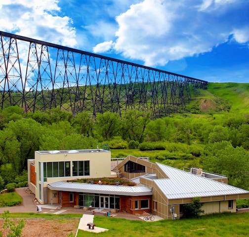
An iconic engineering feat rendering beautiful scenes and flair to the scenic backgrounds of Lethbridge.
Great landmark visible from various perspectives while hiking in the coulies or driving around the city.
24 personas del lugar lo recomiendan
Indian Battle Park
Great landmark visible from various perspectives while hiking in the coulies or driving around the city.
A leisurely walk through the beautifully built downtown is definitely a thing to do for history lovers.
Downtown
A leisurely walk through the beautifully built downtown is definitely a thing to do for history lovers.
My favourite campground for a relaxing outing with the family.
Park Lake Provincial Park
Camping, boating, kayaking.
Consejos sobre la ciudad
Costumbres y cultura
OKI
Oki means "Hello" in traditional Blackfoot, and has been adopted as the official greeting of the City of Lethbridge during the UN Year of Indigenous Languages.
Cómo moverse
The city has transit buses to get around the city.
Nice and clean buses that are punctual.